
Packrafter Waldo's 8 Day Trip to the Largest Glacier in Northern Ice Field
Packrafter Waldo Andrés Aguayo Riquelme embarked on a eight day journey to discover the San Quintin glacier with fellow packrafters Andres Mora and Jorge Diaz. Embark on this journey and learn about his experience!
The Start of it All
In September of this year, before leaving on my trip to Puerto Natales. I was contacted by Andres Mora, who last year had attempted a packraft expedition in the area, but the weather was not so friendly and his attempt failed.
It took almost a year for Andres to plan another expedition in the Aysen region. This time, inviting me to be part of it. How could I refuse this invitation? The destination was to the largest glacier in the Northern Ice Field, the "San Quintín".
After several years of working as a guide in Laguna San Rafael and the national park, the San Quintín glacier was on my list of pending trips. Together with Andrés Mora and Jorge Diaz, we embarked for eight days in one of the most beautiful and wild scenery that Chilean Patagonia can offer.

The Expedition
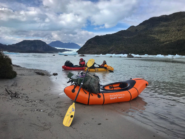
Andres and Jorge arrived on October 31st in the town of Puerto Rio Tranquilo. We started the trip by vehicle from the town to Exploradores Bay and we boarded the "Destino Patagonia" tour boat, which brings you to Laguna San Rafael. Around noon, my friends Eduardo Carrillo and Alvaro Martinez, and the boat crew, left us on the beach. They continued their tour and we were already on the road to begin what would be eight days of long paddling and hiking.

We camped on the beach and started early the next day, to complete the crossing of the "Isthmus of Ofqui". On November 2, we did about 28 km in a span of 12 hours. We walked for 2 hours from Laguna San Rafael, through the tracks left by the works of the

We arrived at the beach of Golfo de San Esteban, which is part of the famous Golfo de Penas and overlooks the sea and the Northern Ice Field. The San Quintín Glacier was already visible and in a kind of trance. We then went up 8km of the Nevados river to reach the Pro-Glacier lake on the main face of the San Quintin and camped.
We were very lucky with the water level brought by the river, this can vary greatly depending on rainfall and melting of the icebergs coming from the glacier. In a day of 6 hours, we managed to reach the Lake-Pro glacier. The amount of icebergs was impressive. We paddled 5 km more between the icebergs, to find one of the most unreal camps I have ever been.

On November 5, we paddled 5 km more between icebergs, to make a crossing of almost 4 km to another Pro-Glacier lake, where two "arms" of the San Quintín fall. In the first 200 meters of walking through the mountain, we were trapped for about 4 hours. The Panorama was quite hard, but we found a better path to make the remaining couple of kilometers, in a couple of hours. We arrived that same day to the small lake where these glaciers fell. It was a very hard day, and the reward was indescribable. We were in one of the most remote points of the expedition, in a sector very little visited by man, on small white sandy beaches, surrounded by evergreen forest and with a view of the Northern Ice Field.

On November 6, we knew that one of the difficult sections would be the crossing that we made yesterday and the descent of the Blanco River that we would make today. Prior to the expedition I had a call with my friend Isaí Madriz, Entomologist and explorer. Isaí had done a route similar to ours and helped me to identify the most dangerous points of the expedition. The Blanco River was at the top of the list.
Knowing this we started the descent of the river, which on Google Earth and other maps, it appears as "Cajas" river. The river has sections that are quite normal to other rivers. However, some sections of the river had logs that were blocking the path. To prioritize the safety of the group, we passed through a section by portage. One of the most dangerous points is in the river Delta, where a bad choice of route can lead you to a place where you would not want to end up with your packraft.

The arrival at the confluence with the San Tadeo River was a relief. We had already passed the most dangerous point of the expedition and with one day of expedition left to reach Laguna San Rafael, we already felt at home.
The next day, we went up the river and walked through the peat bogs. We arrived at San Rafael, where on November 8 we would be picked up by the boat that would take us back to Exploradores and then home to Puerto Rio Tranquilo.
Acknowledgments
First, I would like to thank Andres and Jorge for inviting me to be part of their expedition, for the motivating conversations about books and expeditions in Patagonia. I want to thank all the people who have been involved in teaching me and sharing their knowledge. I had to apply everything I have learned over the years in eight days.
As always, I want to thank my family and friends for their kind vibes before and after the expedition, the brands that have supported me, Level Six, Patagonia Raft and Coffee Jam. And to finish by thanking Patagonia itself, which on this occasion gave us wonderful conditions to achieve this expedition.

Waldo Andrés Aguayo Riquelme